|
INSTITUTE FOR THE APPLICATION OF GEOSPATIAL TECHNOLOGY
at Cayuga Community College, Auburn, New York |

|
INSTITUTE FOR THE APPLICATION OF GEOSPATIAL TECHNOLOGY
The Institute for the Application of Geospatial Technology at Cayuga Community College, Inc. (IAGT) is a non-profit organization that was created in 2001 by the governing council of NASA’s Regional Application Center for the Northeast (RACNE). IAGT is dedicated to promoting the wisest possible use of geospatial information technologies within the spheres of government, education, and commerce, with a particular focus on environmental issues, water resource management and climate change, both within the United States and internationally.
IAGT carries out its charge by:
By enabling the practical application of advanced technologies made available by NASA and other sources, the potential for GIT to address and improve literally every aspect of our lives is enormous. IAGT and its collaborators inspire and encourage the exchange of talents, knowledge, skills and ideas from many perspectives; help define needs and, with the strategic use of geospatial tools, develop solutions that ultimately assist decision makers and benefit society.
Use the links below to view specific information regarding the Institute.
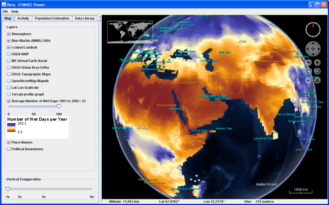
The IAGT will and CIESIN provide Climate & Health ANalysis for Global Education (CHANGE Viewer) technology, an online software tool developed by the Institute for the Application of Geospatial Technology (IAGT) and the Center for International Earth Science Information Network (CIESIN) at Columbia University with a grant from NASA’s Innovations in Climate Education Initiative.
The Institute for the Application of Geospatial Technology at Cayuga Community College, Inc. (IAGT) is a non-profit organization that was created in 2001 by the governing council of NASA’s Regional Application Center for the Northeast (RACNE). IAGT is dedicated to promoting the wisest possible use of geospatial information technologies within the spheres of government, education, and commerce, with a particular focus on environmental issues, water resource management and climate change, both within the United States and internationally.
IAGT carries out its charge by:
- Identifying current and potential geospatial information technology (GIT) users and their needs
- Developing custom GIT solutions by leveraging a wide variety of technologies including: Geographic Information Systems (GIS); satellite, aerial and terrestrial remote sensing; the Global Positioning System (GPS); geospatial analyses and modeling; interactive 3 dimensional visualization; and web mapping services
- Modifying and integrating these solutions through applied research to create end-to-end prototype systems to meet the needs of end users
- Conducting extensive educational, training, and outreach activities to promote the use of GIT, and
- Forming partnerships with governmental academic, and commercial organizations
By enabling the practical application of advanced technologies made available by NASA and other sources, the potential for GIT to address and improve literally every aspect of our lives is enormous. IAGT and its collaborators inspire and encourage the exchange of talents, knowledge, skills and ideas from many perspectives; help define needs and, with the strategic use of geospatial tools, develop solutions that ultimately assist decision makers and benefit society.
Use the links below to view specific information regarding the Institute.
The IAGT will and CIESIN provide Climate & Health ANalysis for Global Education (CHANGE Viewer) technology, an online software tool developed by the Institute for the Application of Geospatial Technology (IAGT) and the Center for International Earth Science Information Network (CIESIN) at Columbia University with a grant from NASA’s Innovations in Climate Education Initiative.